
Keywords: Airborne Laser Scanning (ALS), Machine Learning, Carbon Credits
Date of Publication: December 15, 2025 (in press)
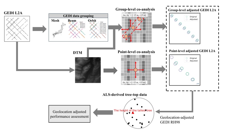
The Global Ecosystem Dynamics Investigation (GEDI), a spaceborne laser altimetry mission operated by NASA aboard the International Space Station, provides critical three-dimensional measurements of forest height and structure worldwide. However, GEDI observations are affected by positional errors of approximately 10 meters in the geolocation of footprint coordinates. These errors can lead to substantial spatial mismatches when GEDI data are compared with high-resolution satellite imagery or airborne laser scanning (ALS) data, resulting in significant uncertainties in forest biomass estimation.
To address this issue, a research group led by Professor Tomomichi Kato of the Research Faculty of Agriculture, Hokkaido University, in collaboration with Mr. Hantao Li and Associate Professor Takuya Hiroshima of the Graduate School of Agricultural and Life Sciences, the University of Tokyo, the National Institute for Environmental Studies (NIES), and George Mason University (USA), developed a new method to improve the geolocation accuracy of GEDI observations. The method uses nationwide 1-meter resolution digital terrain model (DTM) data provided by the Geospatial Information Authority of Japan. For the corrections, the team employed two methods: point-based correction, which adjusts each observation point individually, and group-based correction, which applies corrections collectively to points acquired along the same orbit or beam (Figure 1).
As a result, out of approximately 2.7 million observation points nationwide, 1.84 million points were successfully corrected. In particular, the point-based correction almost completely eliminated positional offsets. Furthermore, comparison with tree height data obtained from ALS showed a substantial improvement in tree height estimation accuracy, with the correlation coefficient increasing from 0.38 to 0.71 (Figure 2).
These results are important for accurately quantifying carbon uptake by forests and are expected to make a significant contribution to future forest management and climate change research.
Source of Citation: Li H, Li X, Hiroshima T, Li X, Kato T, Hayashi M, 2025: Improving GEDI Geolocation Accuracy with Ultra-High-Resolution DTM Data in Japan, GIScience & Remote Sensing, 62(1), 2601327
Website: https://www.tandfonline.com/doi/full/10.1080/15481603.2025.2601327#abstract

(a) Before coordinate correction;
(b) After coordinate correction (group-based correction);
(c) After coordinate correction (point-based correction).